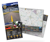
Kansas, Oklahoma and the Texas Panhandle
USRT070
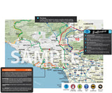
Central Plains road trip map: 30 best road trips in combo Kansas map, Oklahoma map and Texas Panhandle map. Weekend getaways? Our road trip planner gets you on the road with ease.
Our local MAD scouts have discovered the best scenic highways and scenic byways of the region. They also told us of the best places to hang out and stop along the routes. There's actually some pretty diverse terrain in these parts. Attractions include Clinton State Park in Kansas, incredible Grand Lake O' the Cherokees in Oklahoma or Palo Duro Canyon, nicknamed the "Grand Canyon of Texas." And what about lively roadhouses and fun roadside attractions? We've got you covered.
There's plenty to see in this part of the world. Check it out today. MAD Maps™ road trip maps are available in traditional, foldable, tear-proof paper. If you're interested in making it a customized, single-sided, wall map... click here.
Coverage Area:
| NORTH | SOUTH | EAST | WEST |
| KS state line | OK state line | OK state line | TX state line |
US Road Trip MAD Maps Feature:
- Scenic Day and Overnight Road Trips
- 24-35 Trip Options Per Map with Directions
- Convenient Size: 4” x 9” – (FOLDED)
- Open Size: 27" x 36" - (UNFOLDED)
- Color-Coded Routes
- Water & Tear-Resistant Paper
- Hand-Picked Routes from Local Scouts
- Must See Roadside Attractions
- Campgrounds, Recreational Areas, and Outfitters
- Historical Anecdotes and Entertaining Insights
Best maps for riders
It may seem weird -- in this digital world — to count on paper maps to create better riding experiences and road trips, but this is exactly why Mad Maps exists and are so remarkable. They are not about the fastest or shortest routes but all about the best scenic and winding roads for motorcycles enthusiasts. Plus they are waterproof ans dont need a cell connection to work well. Once you experienced them you will never plan a trip and leave without them!
Want more
Then map was great nhowever I’m asked about downloading to my GPSb and never got a response.


